Explanatory notes:
Scroll down below this section for forecast.


Figure 2.Satellite loop of Tropical Cyclone Marcus.
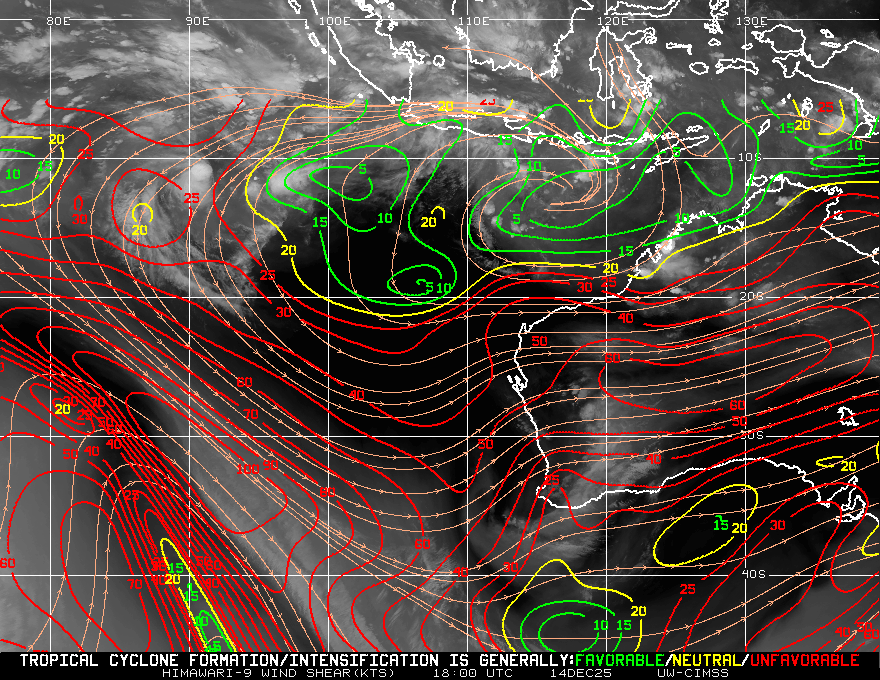
Figure 3.Tropical Cyclone Marcus rapidly weakens during the weekend as it will be entering a region of high vertical wind shear and also lower sea surface temperatures

Figure 4.Tropical Cyclone Marcus rapidly weakens during the weekend as it will be entering a region of high vertical wind shear and also lower sea surface temperatures


Figure 5.Mean Sea Level Pressure(MSLP) analysis with infrared greyscale satellite image at 06 UTC(2 PM local time today).Image courtesy of the Australian Bureau of Meteorology(BOM).

Tropical Cyclone Marcus rapidly is weakening as it will be entering a region of high vertical wind shear and also lower sea surface temperatures.Track the tropical cyclone at http://perthweatherinfo.weebly.com/marcus.html.
Plenty of middle and high level clouds occurred today associated with moisture aloft from Tropical Cyclone Marcus.Rain,showers and drizzle possible at times.
Plenty of middle and high level clouds occurred today associated with moisture aloft from Tropical Cyclone Marcus.Rain,showers and drizzle possible at times.
Also a somewhat east-southeast pressure gradient.
Further middle and high level clouds tomorrow with plenty of virga expected tomorrow,whether or not it reaches the ground depends on how much dry air is present below the clouds.Cannot rule out a thunderstorm.
The remnants of Tropical Cyclone Marcus likely to move over the region on Monday,the low pressure center passing just south of the Perth Area.There is no need to be alarmed as the cyclone would be quite weak then as it rapidly weakens during the weekend upon encountering cool sea surface temperatures and vertical wind shear associated with the subtropical jet stream.
A low pressure trough to the north of the remnant low will bring showers to the Perth Area.
Cooler air mass then lies over the region with sunny conditions by Tuesday afternoon with a ridge of high pressure building to the south.
Warming conditions towards the end of the working week as a west coast trough forms near the west coast with some warm air advection.
The rest of Saturday March 24:

Perth metropolitan area:
City:
Possible shower.
Chance of any rain:30%
Perth metropolitan area:
Becoming cloudy,high clouds.A slight(30%) chance of rain and showers.Winds southeasterly at 20-30 km/h becoming east-southeasterly later at night.
Sunday March 25:

Perth metropolitan area:
Sunday March 25:
City:
19-28 Degrees Celsius
Possible showers.
Chance of any rain:40%
Amount:0 to 1 mm.
Perth metropolitan area:
Cloudy.A medium(40%) chance of rain and showers.The chance of a thunderstorm.Winds easterly at 20-30 km/h tending 15-25 km/h in the afternoon and evening increasing to 25-40 km/h at night becoming northeasterly later at night.
Monday March 26:

Perth metropolitan area:
Monday March 26:
City:
22-27 Degrees Celsius
Showers.
Chance of any rain:80%
Amount:1 to 4 mm.
Perth metropolitan area:
Cloudy.A very high(90%) chance of showers in the southwest grading to a high(70%) chance in the northeast.Winds northerly at 10-20 km/h becoming north-northwesterly at 20-30 km/h before dawn becoming westerly at 25-35 km/h then southwesterly becoming south-southwesterly at 15-25 km/h at night.
Tuesday March 27:

Perth metropolitan area:
Tuesday March 27:
City:
17-24 Degrees Celsius
Clouds clearing.
Chance of any rain:20%
Amount:0 mm.
Perth metropolitan area:
Partly to mostly cloudy with a slight(20%) chance of showers in the early hours and morning then sunny.Winds south-southeasterly at 10-25 km/h tending south-southwesterly at 20-30 km/h in the afternoon and evening becoming southerly at 10-20 km/h at night.
Wednesday March 28:

Perth metropolitan area:
Wednesday March 28:
City:
13-25 Degrees Celsius
Sunny.
Chance of any rain:0%
Amount:0 mm.
Perth metropolitan area:
Sunny.Winds east-southeasterly at 10-20 km/h becoming south-southwesterly at 20-30 km/h from afternoon becoming south-southeasterly at 10-20 km/h at night.
Thursday March 29:
Perth metropolitan area:
Thursday March 29:
City:
14-28 Degrees Celsius
Sunny.
Chance of any rain:0%
Amount:0 mm.
Perth metropolitan area:
Sunny.Winds southeasterly at 10-20 km/h tending south-southwesterly at 20-30 km/h in the afternoon and evening.
Friday March 30:
Perth metropolitan area:
Friday March 30:
City:
16-31 Degrees Celsius
Sunny.
Chance of any rain:0%
Amount:0 mm.
Perth metropolitan area:
Sunny.Winds east-southeasterly at 20-30 km/h tending 10-20 km/h in the afternoon and evening.
Saturday March 31:
Perth metropolitan area:
Saturday March 31:
City:
18-31 Degrees Celsius
Sunny.
Chance of any rain:0%
Amount:0 mm.
Perth metropolitan area:
Sunny.Winds southeasterly at 15-25 km/h.
Forecast produced at 2:00 PM Saturday March 24.Weather icons courtesy of the US National Weather Service.