Effective as of 4:00 AM Monday November 9 2020
Explanatory notes:From today, a more September or even winter like pattern compared to November.
A significant cold front brings showers and possible thunderstormstoday with showers, possible thunderstorms and/or small hail in the deep cold air mass behind the cold front, easing early on Tuesday with the depth of the cold air mass decreasing.
The Australian Bureau of Meteorology(BOM) has issued a severe weather warning valid on Monday for damaging winds and heavy rainfall including the southern parts of the Perth Metropolitan Area. View the latest warning at http://www.bom.gov.au/products/IDW21037.shtml .
Partly to mostly cloudy conditions on Wednesday, Thursday with a ridge of high pressure to the northwest, over the region.
Another cold front likely moves over the region on Friday bringing showers, it likely remains showery during the weekend with westerly flow, embedded cold fronts and troughs possible.
Monday November 9:
City:
13-21 Degrees Celsius
Showers.Possible thunderstorm.
Chance of any rain:100%
Amount:10 to 25 mm
Perth Metropolitan Area:
Partly to mostly cloudy.A very high(100%) chance of showers. The chance of a thunderstorm. Possible small hail from evening. Winds north-northeasterly at 10-20 km/h shifting northwesterly at 20-30 km/h in the morning shifting westerly at 30-45 km/h around the middle of the day becoming southwesterly at 20-30 km/h from evening.Gusty winds possible.
Note:The Australian Bureau of Meteorology(BOM) has issued a severe weather warning valid on Monday for damaging winds and heavy rainfall including the southern parts of the Perth Metropolitan Area. View the latest warning at http://www.bom.gov.au/products/IDW21037.shtml .
Tuesday November 10:
City:
10-19 Degrees Celsius
Showers easing.
Chance of any rain:80%
Amount:2 to 6 mm
Perth Metropolitan Area:
Partly to mostly cloudy.A very high(90%) chance of showers easing to a slight(30%) chance by afternoon. The chance of a thunderstorm and/or small hail in the early hours. Winds southwesterly at 20-30 km/h.
Wednesday November 11:
City:
10-20 Degrees Celsius
Mostly cloudy.
Chance of any rain:10%
Amount:Nil
Perth Metropolitan Area:
Mostly cloudy.Light winds tending southwesterly at 10-20 km/h in the afternoon.
Thursday November 12:
City:
10-22 Degrees Celsius
Partly cloudy.
Chance of any rain:10%
Amount:Nil
Perth Metropolitan Area:
Partly cloudy.Light winds becoming northwesterly at 15-25 km/h during the day.
Friday November 13:
City:
15-22 Degrees Celsius
Showers.
Chance of any rain:80%
Amount:1 to 5 mm
Perth Metropolitan Area:
Partly to mostly cloudy.A high(80%) chance of showers.Winds northwesterly at 20-30 km/h shifting west-southwesterly at 15-25 km/h by morning.
Saturday November 14:
City:
14-22 Degrees Celsius
Showers.
Chance of any rain:80%
Amount:1 to 5 mm
Perth Metropolitan Area:
Partly to mostly cloudy.A high(80%) chance of showers.Winds westerly at 15-30 km/h.
Cha

Figure 1.Surface synoptic chart at 12 UTC(8 PM local time yesterday).Image courtesy of the Australian Bureau of Meteorology(BOM).
2.

The Australian Bureau of Meteorology(BOM) has issued a severe weather warning valid on Monday for damaging winds and heavy rainfall including the southern parts of the Perth Metropolitan Area. View the latest warning at http://www.bom.gov.au/products/IDW21037.shtml .

Figure 2.Key features identified on True Colour RGB satellite image at around 06:00 UTC(2 PM local time yesterday).Satellite image courtesy of the Japanese Meteorological Agency(JMA).

local time yesterday).Image courtesy of the Australian Bureau of Meteorology(BOM)

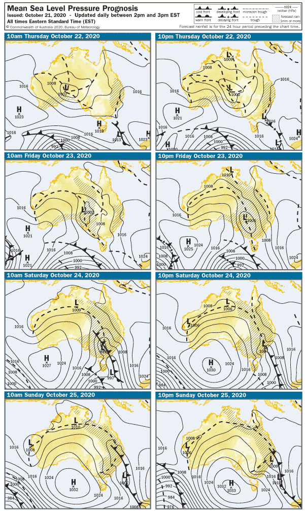
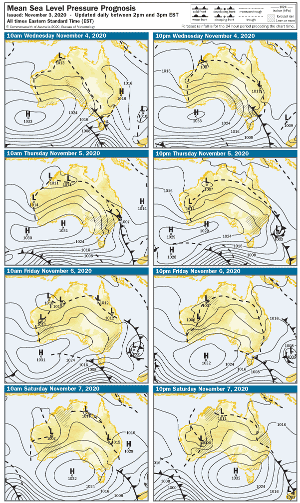
Figure 4:Surface synoptic prognosis.Image courtesy of the Australian Bureau of Meteorology(BOM).