Effective as of 4:00 PM Wednesday April 21 2021
Explanatory notes:
Subtropical high pressure ridge lies to the south. As at 4 PM, southeasterly prevailing winds with a souh-southwesterly sea breeze over western suburbs. Some prescribed burns have been conducted to the southeast, with the east-southeasterly gradient flow, possible smoke haze with possible visibility and air quality reductions should the smoke haze get trapped under a nocturnal inversion. Given that most of the prescribed burns are so far to the southeast, the smoke haze would be expected to contract towards the southern areas as the gradient flow turns more easterly tonight and east-northeasterly by tomorrow morning. Possible smoke haze again from late afternoon if there are prescribed burns to the southeast, as winds tend southeasterly in the late afternoon and evening.
The west coast trough deepens off the coast from tomorrow with warm air advection. An upper level trough approaches from the west leading to some high and middle level clouds. Warm to hot from the weekend with the warm air advection and the hot air mass over the region but the decreasing solar insolation as autumn progressing is certainly having its impact (it would be much hotter if this weather pattern occured earlier in the year). Despite the hot afternoons, cool to cold early mornings with the lengthening night and dry air allowing for very good radiational cooling.
Some uncertainty whether or not the west coast trough moves inland temporarily from Saturday afternoon advecting the moist marine layer over the region with the ECMWF having the marine layer advecting inland but the GFS not, it would be a warm to hot afternoon nevertheless.
Possible smoke haze at times depending on prescribed burning activities, air quality and visibility reductions most likely overnight and in the mornings with the nocturnal inversion. Gradient flow shifts to be a northerly direction from Friday meaning that prescribed burns to the north particularly over the Gnangara-moore River State Forest would be the potential source of any smoke haze.
The west coast trough likely moves inland from Monday and Tuesday with the subtropical ridge lying just slightly north leading to moist onshore flow.
Chance of any rain:0%
Perth Metropolitan Area:
High clouds (mostly clear).Possible smoke haze.Winds southeasterly at 10-20 km/h with a south-southwesterly sea breeze at 15-25 km/h over western suburbs becoming east-southeasterly at 10-20 km/h at night.
Partly cloudy.
Chance of any rain:0%
Amount:Nil.
Perth Metropolitan Area:
Partly cloudy.High clouds.Possible smoke haze early and again in the evening most likely over southern suburbs depending on prescribed burning activites.Winds easterly at 15-25 km/h tending southeasterly in the late afternoon and evening.
Partly to mostly cloudy.
Chance of any rain:5%
Amount:Nil.
Perth Metropolitan Area:
Partly to mostly cloudy.Winds easterly at 15-25 km/h becoming northeasterly in the morning tending south-southwesterly at 10-20 km/h in the afternoon becoming light at night.
Partly cloudy.
Chance of any rain:5%
Amount:Nil.
Perth Metropolitan Area:
Partly cloudy.Light winds becoming northeasterly at 10-20 km/h in the morning becoming northwesterly then rgadually becoming southwesterly at 10-20 km/h in the afternoon becoming light at night.
Mostly sunny.
Chance of any rain:0%
Amount:Nil.
Perth Metropolitan Area:
Mostly sunny.Light winds tending southwesterly at 10-20 km/h in the afternoon.
Partly cloudy.
Chance of any rain:0%
Amount:Nil.
Perth Metropolitan Area:
Partly cloudy.Winds east-northeasterly at 10--20 km/h tending southwesterly at 10-20 km/h in the afternoon.
Partly cloudy.
Chance of any rain:5%
Amount:Nil.
Perth Metropolitan Area:
Charts:
Figure 1.Surface synoptic chart.Image courtesy of the Australian Bureau of Meteorology(BOM).
2.
Figure 2.Key features identified on True Colour RGB satellite image.Satellite image courtesy of the Japanese Meteorological Agency(JMA).
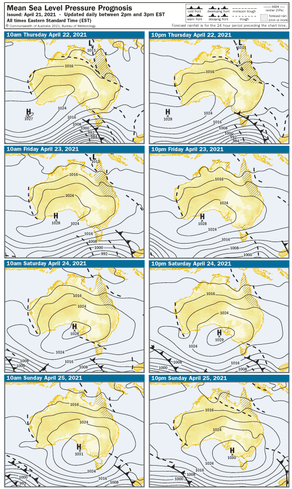
Figure 4:Surface synoptic prognosis.Image courtesy of the Australian Bureau of Meteorology(BOM).
No liabilities held from information consumed on this site. Weather icons are from the US National Weather Service.Some information on this site is from the Australian Bureau of Meteorology (BOM).


