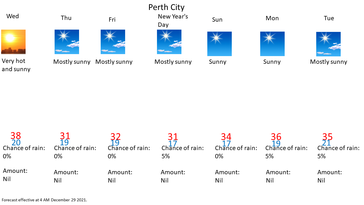
Effective as of 4:00 AM Wednesday December 29 2021
View the latest severe weather warnings from BOM at http://www.bom.gov.au/wa/warnings/ .


Explanatory notes:
Perth has seen the longest 40+°C spell on record for December and even for any month drawing with 4 consecutive days in February 2016 and February 1933.This is part of an unusual December heatwave that is arguably the worst on record for December and second worst on record for any month (with the February 1933 heatwave arguably being the worst on record). Perth has never seen 4 consecutive 40+°C days outside of February. The previous record longest 40+°C spell in December was 3 consecutive days in December 2019 and December 2020 where that was unheard of in December prior to December 2019.
If maximum temperatures exceed forecasts again today to exceed 40.0°C, Perth would beat the previous record number of consecutive 40+°C days for any month on record. However, the sea breeze is expected to be stronger and to make an earlier onset relative to yesterday.
On average Perth is hotter in February than in December where December's tend to be milder with fresh afternoon sea breezes, however, Perth is on track to seeing 3 consecutive December's whose mean maximum temperature is higher than the February average. Perth is on track to see the second or third hottest December on record where the current hottest on record was December 2019 and second hottest on record was December 2020 (drawing with December 1931).
In addition, it was also the hottest Christmas Day on record for any Australian capital city and perhaps for any major city in the world while Boxing Day was the second hottest December day on record and hottest since Boxing Day 2007.
The heatwave ends by Thursday but mroe humid as the west coast trough moves inland with the marine layer advecting onshore but not that much relief with the air mass aloft remaining quite hot.
Likely hot again early next week but still plenty of uncertainty on the details this far out.