Current(Perth Metro)


Radar


Thursday, 27 January 2022

7 day weather forecast

Effective as of 12:00 AM Thursday January 27 2022

View the latest severe weather warnings from BOM at http://www.bom.gov.au/wa/warnings/ .


Explanatory notes:


Perth had seen 6 consecutive days with a maximum temperature above 40°C which is the longest 40+°C spell on record for any month, beating the previous record of 4 consecutive days in February 1933, February 2016 and December 2021 by a margin. Prior to December 2021, Perth has not seen 4 or more consecutive 40+°C outside of December.

It is in fact the longest 40°C spell on record for any Australian capital city, drawing with Adelaide, with records going back to the 19th century.

6 40+°C days in total in a calendar month is also the record highest beating the previous record of 5 days just set in December 2021.

Perth has seen 11 40+°C days this summer so far, breaking the previous record for the entire summer of 7 by a large margin and summer is far from over.

The heatwave was due to a hot air mass and the west coast trough lingering over the region with subsidence heating below an upper level anticyclone aloft. Climate change was also very likely to have been a necessary causal factor.

Some respite until tomorrow as cooler air had moved in from the southeast, still hot days but much less hot and cooler nights with cool air advection from the southeast.

Becoming very hot again towards the weekend as the west coast trough deepens off the west coast, also the slight possibility of convection with steep vertical lapse rates, most likely over the hills.

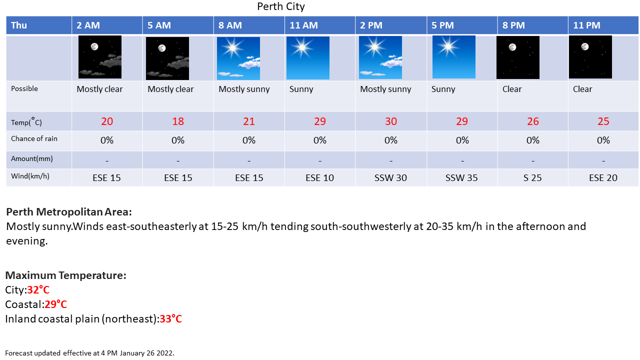

Thursday January 27:
City:
18-32  Degrees Celsius
Mostly sunny.
Chance of any rain:0%
Amount:Nil


Perth Metropolitan Area:
Mostly sunny.Winds east-southeasterly at 15-25 km/h tending south-southwesterly at 20-35 km/h in the afternoon and evening.

Friday January 28:
City:
17-35  Degrees Celsius
Sunny.
Chance of any rain:0%
Amount:Nil


Perth Metropolitan Area:
Sunny.Winds east-southeasterly at 20-30 km/h easing to 15-25 km/h in the morning tending south-southwesterly at 20-30 km/h in the afternoon and evening.

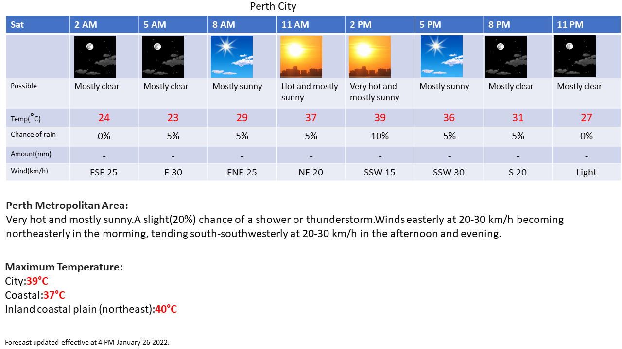
Saturday January 29:
City:
23-39  Degrees Celsius
Very hot and mostly sunny.
Chance of any rain:20%
Amount:Nil


Perth Metropolitan Area:
Very hot and mostly sunny.A slight(20%) chance of a shower or thunderstorm.Winds easterly at 20-30 km/h becoming northeasterly in the morning, tending south-southwesterly at 20-30 km/h in the afternoon and evening.

Sunday January 30:
City:
24-39  Degrees Celsius
Very hot and mostly sunny.
Chance of any rain:10%
Amount:Nil


Perth Metropolitan Area:
Very hot and mostly sunny.A slight(20%) chance of a shower or thunderstorm over the hills.Winds northeasterly at 10-20 km/h tending south-southwesterly at 15-25 km/h in the afternoon, becoming light at night.

Monday January 31:
City:
23-39  Degrees Celsius
Very hot and mostly sunny.
Chance of any rain:5%
Amount:Nil


Perth Metropolitan Area:
Very hot and mostly sunny.Winds southeasterly at 15-25 km/h increasing to east-southeasterly at 20-30 km/h at night.

Tuesday February 1:
City:
18-36  Degrees Celsius
Mostly sunny.
Chance of any rain:5%
Amount:Nil


Perth Metropolitan Area:
Mostly sunny.Winds east-southeasterly at 20-30 km/h.

Wednesday February 2:
City:
18-35  Degrees Celsius
Mostly sunny.
Chance of any rain:5%
Amount:Nil


Perth Metropolitan Area:
Mostly sunny.Winds easterly at 20-30 km/h easing to 10-20 km/h in the afternoon.


Charts:


Figure1.


Figure 2.


Figure 3.


Figure 4.

No liabilities held. Some information on this site is sourced from the Australian Bureau of Meteorology. Weather icons are from the National Weather Service.