Current(Perth Metro)


Radar


Thursday 10 February 2022

7 day weather forecast

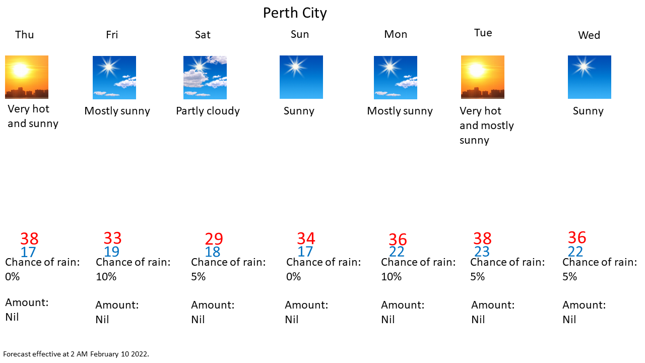
 Effective as of 2:00 AM Thursday February 10 2022


Explanatory notes:


As at 2 AM, boundary layer decoupling leading to temperatures dipping below forecast is giving way with increasing easterly winds and will lead to slightly increased temperature once winds establish as the temperature inversion is disrupted.

Becoming hot again today as a hot air mass advects over the region with the west coast trough deepening offshore before moving inland on Friday bringing cooler conditions whilst tropical moisture moving down combined with atmospheric instability from steep vertical lapse rates with the hot air mass near the surface will result in thunderstorms developing inland such as over the hills and over the Wheatbelts, however, the marine temperature inversion and northwesterly steering flow should keep the city and coastal areas dry.

Becoming hot again next week with the subtropical high pressure ridge to the south the west coast trough deepening offshore.

The Mt Lawley site had seen the hottest January on record with a mean maximum temperature of 33.7°C beating the record of 33.5°C set in January 2012.

It was the hottest January at the official Perth station since January 1962. 

Perth saw 6 consecutive 40+°C days, the longest such spell beating the previous record of 4 consecutive days which prior to December 2021 was not seen outside of February. 6 consecutive 40+°C days is also the longest such spell on record for any Australian capital city drawing with Adelaide in 2009 and 1908.

Six consecutive days with maximum temperatures of 41+ °C occurred at Perth Airport and Pearce RAAF which was their all-time record beating the previous record of 3 and 5 consecutive days respectively.

Bickley recorded 6 consecutive days with maximum temperatures of 38+°C, the longest such spell on record beating the record of 5 such consecutive days in January 2007.

Perth Metro's minimum temperature of 26.7 °C on the 19th was its highest minimum temperature for 7 years since 12 January 2014, the all time record of 29.7°C whilst Swanbourne saw it's highest January minimum temperature on record.

So far, the total number of 40+°C days this summer at the Mt Lawley site is 13, almost double the previous record of 7 such days for an entire summer and the current summer isn't even over yet.


Thursday February 10:
City:
17-38  Degrees Celsius
Very hot and sunny.
Chance of any rain:0%
Amount:Nil


Perth Metropolitan Area:
Very hot and sunny.Winds east-southeasterly at 15-25 km/h becoming easterly by morning becoming south-southwesterly at 20-30 km/h in the afternoon, easing to 10-20 km/h at night.

Friday February 11:
City:
19-33  Degrees Celsius
Mostly sunny.
Chance of any rain:10%
Amount:Nil


Perth Metropolitan Area:
Mostly sunny.A slight(20%) chance of a shower or thunderstorm over the hills from afternoon.Light winds becoming west-northwesterly at 10-20 km/h by late morning, southwesterly at 15-25 km/h by afternoon and south-southwesterly in the evening.

Saturday February 12:
City:
18-28  Degrees Celsius
Partly cloudy.
Chance of any rain:5%
Amount:Nil


Perth Metropolitan Area:
Partly cloudy.Winds south-southeasterly at 10-20 km/h tending south-southwesterly at 20-30 km/h in the afternoon and evening becoming east-southeasterly at 15-25 km/h later at night.

Sunday February 13:
City:
17-34  Degrees Celsius
Sunny.
Chance of any rain:5%
Amount:Nil


Perth Metropolitan Area:
Sunny.Winds east-southeasterly at 15-25 km/h tending south-southwesterly in the afternoon.

Monday February 14:
City:
22-36  Degrees Celsius
Mostly sunny.
Chance of any rain:10%
Amount:Nil


Perth Metropolitan Area:
Mostly sunny.Very hot inland.Winds east-northeasterly at 15-25 km/h tending south-southwesterly in the afternoon and evening.

Tuesday February 15:
City:
23-38  Degrees Celsius
Very hot and sunny.
Chance of any rain:5%
Amount:Nil


Perth Metropolitan Area:
Very hot and sunny.Winds east-northeasterly at 15-25 km/h tending southerly in the afternoon and evening.

Wednesday February 16:
City:
22-36  Degrees Celsius
Sunny.
Chance of any rain:5%
Amount:Nil


Perth Metropolitan Area:
Sunny.Very hot inland.Winds east-northeasterly at 15-25 km/h tending south-southwesterly at 20-30 km/h in the afternoon and evening becoming east-southeasterly at 15-25 km/h at night.


Charts:


Figure 1.Mean Sea Level Pressure (MSLP) chart.Image courtesy of the Australian Bureau of Meteorology (BOM).


Figure 2.Annotated satellite image.Satellite image courtesy of the Japanese meteorological Agency, annotation by me.


Figure 3.Annotated infrared satellite image.Image courtesy of the Australian Bureau of Meteorology (BOM).


Figure 4.Prognosis charts.Image courtesy of the Australian Bureau of Meteorology (BOM).


No liabilities held for information consumed on this site. Some data is from the Australian Bureau of Meteorology (BOM). Weather icons are from the US National Weather Service.