Effective as of 12:00 AM Tuesday May 18 2021
Explanatory notes:
Some intense thunderstorms occurred near Mandurah yesterday with waterspouts spotted and wind gusts to 59 km/h occurred at Mandurah. This occurred in a moist and highly unstable within the vicinity of a trough.
Further showers and thunderstorms possible today with the surface trough and moisture and instability remaining over the region but instability and vertical wind shear would be less compared to yesterday
Ridge of high pressure likely builds to the south from Wednesday leading to improving conditions with a west coast trough deepening near the west coast thereafter.
Possible fog early today and on Wednesday depending on cloud cover with moist low level air and moist soils from earlier rain.
A significant cold front moves over the region on Saturday with a cold and unstable air mass in its wake.
Tuesday May 18:
City:
15-24 Degrees Celsius
Possible shower or thunderstorm or two.
Chance of any rain:40%
Amount:0 to 8 mm
Perth Metropolitan Area:
Partly to mostly cloudy.Areas of fog possible early.A medium (40%) chance of showers.The chance of a thunderstorm.Light winds except with showers thunderstorms.
Wednesday May 19:
City:
12-23 Degrees Celsius
Partly cloudy.
Chance of any rain:20%
Amount:Nil
Perth Metropolitan Area:
Partly cloudy.Areas of fog possible early.A slight(20%) chance of a shower.Light winds tending south-southwesterly at 10-20 km/h in the afternoon becoming southeasterly at night.
Thursday May 20:
City:
11-25 Degrees Celsius
Mostly sunny.
Chance of any rain:0%
Amount:Nil
Perth Metropolitan Area:
Mostly sunny.Light winds tending easterly at 10-20 km/h in the morning tending south-southwesterly at 10-20 km/h in the afternoon
Friday May 21:
City:
11-24 Degrees Celsius
Mostly sunny.
Chance of any rain:20%
Amount:Nil
Perth Metropolitan Area:
Mostly sunny.Light winds tending southwesterly at 10-20 km/h in the afternoon.
Saturday May 22:
City:
13-21 Degrees Celsius
Showers.
Chance of any rain:95%
Amount:6 to 15 mm
Perth Metropolitan Area:
Partly to mostly cloudy.A very high (95%) chance of showers.Winds westerly at 15-30 km/h shifting southwesterly later during the day.
Sunday May 23:
City:
10-18 Degrees Celsius
Showers.
Chance of any rain:95%
Amount:8 to 15 mm
Perth Metropolitan Area:
Partly to mostly cloudy.A very high (95%) chance of showers.The chance of a thunderstormWinds west-southwesterly at 20-30 km/h.
Monday May 24:
City:
10-18 Degrees Celsius
Showers.
Chance of any rain:80%
Amount:3 to 10 mm
Perth Metropolitan Area:
Partly to mostly cloudy.A high (80%) chance of showers.The chance of a thunderstormWinds southwesterly at 15-25 km/h
Charts:

Figure 1.Surface synoptic chart.Image courtesy of the Australian Bureau of Meteorology(BOM).
2.

Figure 2.Key features identified on True Colour RGB satellite image.Satellite image courtesy of the Japanese Meteorological Agency(JMA).


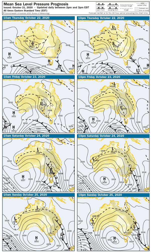
Figure 4:Surface synoptic prognosis.Image courtesy of the Australian Bureau of Meteorology(BOM).
No liabilities held from information consumed on this site. Weather icons are from the US National Weather Service.Some information on this site is from the Australian Bureau of Meteorology (BOM).