Current(Perth Metro)


Radar


Monday 7 February 2022

7 day weather forecast

Effective as of 4:00 PM Monday February 7 2022

View the latest severe weather warnings from BOM at http://www.bom.gov.au/wa/warnings/ .


Explanatory notes:


A significant cold front for February moved across the region bringing some showers and the first rainfall since December for many places with a cool air mass in its wake. Isolated showers in this cool southwesterly air stream occured early today, easing lduring the day as the subtropical high pressure ridge builds to the south.It was a cool day, the coolest since December with the cool southwesterly air stream.

Fine conditions on Tuesday and Wednesday with afternoon sea breezes with the subtropical high pressure ridge to the south and the west coast trough inland.

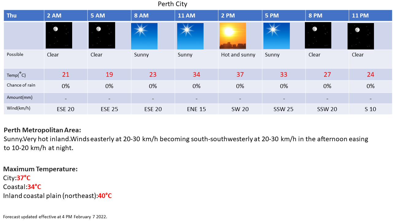
Becoming hot again on Thursday as hot air mass advects over the region with the west coast trough deepening offshore before moving inland on Friday bringing cooler conditions.


Temperature at around 220 meters above sea level at Gooseberry Hills reached some mad 45.5°C on Saturday, the highest within the Perth Area.

Temperatures at other stations were not as hot due to the arrival of the sea breeze.

Perth Airport saw the hottest February day since 1997 with a maximum temperature of 44.1°C.

The Mt Lawley site saw maximum temperatures climb to 42.5°C bringing the total number of 40+°C days this summer to 13, almost double the previous record of 7 such days for an entire summer and the current summer isn't even over yet.


In January, Perth saw 6 consecutive 40+°C days, the longest such spell beating the previous record of 4 consecutive days which prior to December 2021 was not seen outside of February.
6 consecutive 40+°C days is also the longest such spell on record for any Australian capital city drawing with Adelaide in 2009 and 1908.


In December, Perth saw 4 consecutive 40+°C days, the longest such spell in December and the first time such was seen outside of February. That month, Perth had seen 5 40+°C days in total, the then highest number of such days in a month on record before it was beaten by 6 such days in January.


The Mt Lawley site has seen the hottest January on record with a mean maximum temperature of 33.7°C beating the record of 33.5°C set in January 2012.

It was the hottest January at the official Perth station since January 1962. 

Besides the records mentioned above:

Six consecutive days with maximum temperatures of 41+ °C at Perth Airport and Pearce RAAF was their all-time record beating the previous record of 3 and 5 consecutive days respectively.

Bickley recorded 6 consecutive days with maximum temperatures of 38+°C, the longest such spell on record beating the record of 5 such consecutive days in January 2007.

Perth Metro's minimum temperature of 26.7 °C on the 19th was its highest minimum temperature for 7 years since 12 January 2014, the all time record of 29.7°C whilst Swanbourne saw it's highest January minimum temperature on record.


Monday February 7:
City:
16-24  Degrees Celsius
Possible AM shower.
Chance of any rain:30%
Amount:0 to 0.2 mm


Perth Metropolitan Area:
Partly cloudy.A slight(30%) chance of showers clearing by afternoon.Winds southwesterly at 20-35 km/h.

Tuesday February 8:
City:
14-27  Degrees Celsius
Partly cloudy.
Chance of any rain:0%
Amount:Nil


Perth Metropolitan Area:
Partly cloudy.Winds southeasterly at 10-20 km/h becoming light before dawn tending south-southwesterly at 20-30 km/h in the afternoon and evening becoming southerly at 10-20 km/h later at night.

Wednesday February 9:
City:
16-29  Degrees Celsius
Sunny.
Chance of any rain:0%
Amount:Nil


Perth Metropolitan Area:
Sunny.Winds southeasterly at 15-25 km/h tending south-southwesterly at 20-30 km/h in the afternoon and evening.

Thursday February 10:
City:
18-37  Degrees Celsius
Hot and sunny.
Chance of any rain:0%
Amount:Nil


Perth Metropolitan Area:
Sunny.Very hot inland.Winds easterly at 20-30 km/h becoming south-southwesterly at 20-30 km/h in the afternoon easing to 10-20 km/h at night.

Friday February 11:
City:
 -1931 Degrees Celsius
Mostly sunny.
Chance of any rain:10%
Amount:Nil


Perth Metropolitan Area:
Mostly sunny.Light winds becoming south-southwesterly at 15-25 km/h by afternoon.

Saturday February 12:
City:
 -1828 Degrees Celsius
Partly cloudy.
Chance of any rain:20%
Amount:Nil


Perth Metropolitan Area:
Partly cloudy.A slight(20%) chance of a shower.The slight chance of a thunderstorm.Winds southerly at 10-20 km/h tending southwesterly at 20-30 km/h in the afternoon and evening becoming south-southeasterly at 15-25 km/h at night.

Sunday February 13:
City:
 -1733 Degrees Celsius
Sunny.
Chance of any rain:5%
Amount:Nil


Perth Metropolitan Area:
Sunny.Winds east-southeasterly at 15-25 km/h tending south-southwesterly in the afternoon.

Monday February 14:
City:
 -1935 Degrees Celsius
Sunny.
Chance of any rain:5%
Amount:Nil


Perth Metropolitan Area:
Sunny.Winds easterly at 20-30 km/h tending south-southwesterly at 15-25 km/h in the afternoon.

Charts:


Figure1.


Figure 2.


Figure 3.


Figure 4.

No liabilities held. Some information on this site is sourced from the Australian Bureau of Meteorology. Weather icons are from the National Weather Service.